


BOURG-DUN

juanluco76
User
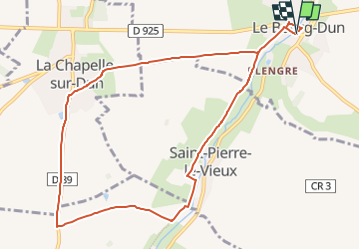

Length
9.6 km

Max alt
67 m

Uphill gradient
93 m
Km-Effort
10.9 km

Min alt
15 m

Downhill gradient
94 m
Boucle
Yes
Creation date :
2024-11-17 22:37:29.534
Updated on :
2024-11-17 22:39:14.323
0m
Difficulty : Very easy

FREE GPS app for hiking
 SityTrail
IGN / Geographical institutes
SityTrail Plus
The world is yours!
About
Trail Walking of 9.6 km to be discovered at Normandy, Seine-Maritime, Le Bourg-Dun. This trail is proposed by juanluco76.
Positioning
Country:
France
Region :
Normandy
Department/Province :
Seine-Maritime
Municipality :
Le Bourg-Dun
Location:
Unknown
Start:(Dec)
Start:(UTM)
348204 ; 5525783 (31U) N.
Comments